The Denver International Airport (DEN) map functions as a detailed navigation tool designed to manage the airport’s large scale. It shows how passengers can move efficiently between terminals, concourses, and gates. The interactive layout also marks parking areas, security checkpoints, dining options, and transportation services. Because the airport covers extensive ground, the DEN map reduces confusion and saves time. It remains accessible through the official airport website, making it especially useful for first‑time travelers
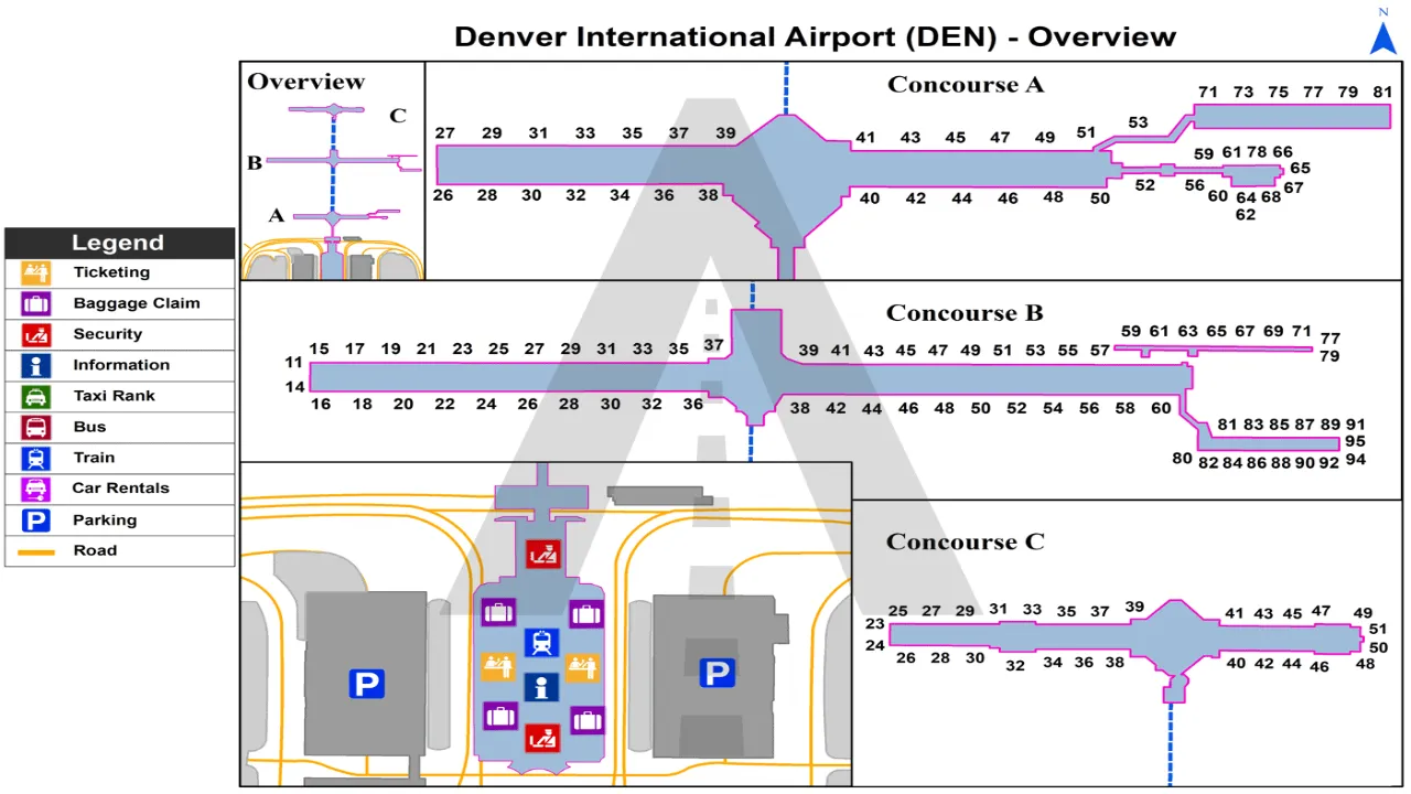
Map of Denver International Airport
The Denver Airport terminal map helps passengers locate:
-
Airline check-in counters
-
Security checkpoints (North & South)
-
Baggage claim areas
-
Ground transportation
-
Rental car shuttles
-
Passenger services and amenities
DEN Jeppesen Terminal Map
Using the Denver Airport terminal map, travelers can easily find:
-
TSA security screening areas
-
CLEAR and TSA PreCheck lanes
-
Ticket counters by airline
-
Information desks
-
Hotel access
-
Bridge Security (pedestrian access to Concourse A)
Denver Airport Concourse A map
The Concourse A map helps passengers locate:
-
Domestic and some international gates
-
International arrivals facility
-
Restaurants and retail shops
-
Restrooms and lounges
Map of Denver Airport Concourse B
Concourse B is the largest concourse at DEN and primarily serves United Airlines.
Through the map, travelers can find:
-
Gate clusters
-
Dining areas and cafés
-
Shopping outlets
-
Passenger service desks
-
Moving walkways
Denver Airport Concourse C Map
Concourse C serves Southwest Airlines and other domestic carriers.
The Concourse C map displays:
-
Gate numbers
-
Food courts and quick-service restaurants
-
Airline counters
-
Family restrooms and accessibility services
Denver Airport (DIA) Parking Map
The DEN parking map allows passengers to locate:
-
East & West Garages
-
Economy Lots
-
61st & Peña Station Parking
-
Pikes Peak Lot
-
Longs Peak Lot
-
Valet parking
The map also shows shuttle routes connecting parking areas to the terminal.
DIA Airport Ground Transportation Map
The Denver Airport map also highlights:
-
RTD A Line commuter rail to downtown Denver
-
Ride-share pickup zones
-
Taxi stands
-
Rental car shuttle pickup areas
-
Hotel shuttles
This helps travelers plan transportation before arriving at the airport.
Frequently Asked Questions
The Denver Airport map clearly marks North and South security checkpoints inside Jeppesen Terminal.
Passengers can walk to Concourse A via the pedestrian bridge. For Concourses B and C, the underground train is required.
Yes. The map provides detailed locations for restaurants, cafés, bars, and retail stores across all concourses.
Denver International Airport has one main terminal (Jeppesen) and three concourses (A, B, and C).
Yes. The map indicates TSA, CLEAR, and PreCheck screening lanes within the terminal.